EXERCISE
Q1. Write in short the locational and geographical characteristics of USA.
Answer: The mainland USA is located in the temperate climatic region, between 66° and 125° West longitude and 25° and 43° North latitude. It is bounded by Canada to the north, the Atlantic Ocean to the east, Mexico to the south, and the Pacific Ocean to the west.
The USA is the fourth largest country in the world, covering about 96 lakh square km. It has a diverse physical structure with mountains, plains, and highlands, and is rich in natural resources. The country is highly socio-economically developed and one of the most powerful nations globally.
Q2. Divide USA into physical divisions. Give a comprehensive description of each of them.
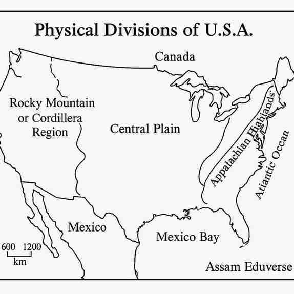
Answer: Based on its physiographic structure, the USA can be divided into three major physical divisions from east to west:
- The Appalachian Highlands: Located along the eastern part of the USA, parallel to the Atlantic Ocean, this is an old mountain range with hills, mountains, plateaus, and plains. The average altitude is below 2,000 meters. Major rivers like the Hudson and Ohio drain the region. It is rich in coal, petroleum, and iron, which have supported the growth of industrial centers.
- The Central Plain: This vast plain lies between the Appalachian Highlands and the Rocky Mountains. It mainly includes the Mississippi-Missouri river basin, making it fertile and ideal for agriculture. The region can be further divided into the Highland Plain, Great Lake Region, Mississippi Plain, and Mexican Coastal Lowlands.
- The Rocky Mountain or Cordillera: Located between the Central Plains and the Pacific Coastal Lowlands, this is a young folded mountain system running north-south. Its topography includes parallel mountain ranges like the Rockies and Sierra Nevada, plateaus such as Columbia and Colorado, and deep valleys. The region is rich in coal, petroleum, gold, silver, and copper.
Q3. Show on a sketch the physical divisions of USA.
Answer:
Q4. Discuss with the help of a sketch the growth and the distribution of population in USA.
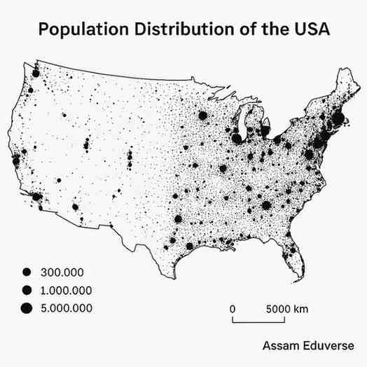
Answer: The population of the USA has grown rapidly, especially after independence, largely due to migration from Europe. It increased from 3 million in 1776 to 302 million in 2007. However, the growth rate is now declining because of a lower natural growth rate and reduced migration.
The distribution of population in the USA is highly uneven. Densely populated areas include the Appalachian Highlands and the Atlantic seaboard in the east, parts of Michigan, and the California coast in the west, where industrialization and urbanization are high. Sparsely populated regions include the Central Plains and the Cordillera region in the west, where rugged terrain and unfavorable climate limit settlement.
Q5. Discuss the role of agriculture in the economy of USA.
Answer: Agriculture plays a significant role in the USA’s economy, even though it contributes only about 2% of the Gross National Income. The country is a global leader in food production, ranking as the top producer of corn, cotton, and tobacco, and the second-highest producer of wheat and barley. It ensures food security by producing a surplus, allowing the USA to export food worldwide. Agriculture also acts as a raw material supplier for industries, such as cotton for textiles and sugarcane for sugar production. With extensive mechanization and modern farming techniques, agricultural productivity per capita is very high.
Q6. What do you mean by agricultural belt? How many agricultural belts have been recognised in USA? Describe them briefly.
Answer: An agricultural belt is a region where a particular crop or type of farming is dominant due to favorable climate, soil, and physiographic conditions.
In the USA, nine major agricultural belts have been recognized:
- Rice and Sugarcane Belt: Located on the Mexican coastal lowlands, with sub-tropical climate and fertile alluvial soil.
- Cotton Belt: Lies north of the Rice and Sugarcane Belt in the southern Mississippi valley; cotton is the main crop.
- Winter Wheat and Tobacco Belt: Extends from the Atlantic coast to Colorado; western part produces winter wheat, eastern part produces tobacco.
- Maize Belt: North of the Winter Wheat Belt, known for large-scale maize cultivation.
- Spring Wheat Belt: Found north of the Prairies; wheat is grown in spring due to cold winters.
- Mixed Agriculture of North East: Around the Great Lakes, includes mixed farming and dairy production.
- Dry Farming and Dairy Belt: Western Central Plains; low rainfall makes it suitable for dry farming and animal rearing.
- Mediterranean Agricultural Belt: California coast; grows citrus fruits, grapes, and apples.
- Mixed Farming Belt of the North West Margin: Northwestern states; wheat, maize, and livestock farming are common.
This division helps in understanding the type of agriculture practiced in different parts of the country and their contribution to the economy.
Q7. Name the major industries of USA and describe one of them.
Answer: The major industries of the USA include iron and steel, automobile, textile, petroleum and chemical, electronics, and aerospace. These industries are concentrated in three major regions:
- North East Industrial Region
- Southern Industrial Region
- Pacific Coast Industrial Region
The North East Industrial Region is the most developed and largest industrial region in the USA. It stretches from the Great Lakes in the north to the Atlantic Coast in the east. Although it covers only 10% of the country’s area, it houses 50% of the population and 75% of the industries. Its growth is supported by abundant coal and iron resources and a well-developed transport network. Major industrial cities include Pittsburgh (iron and steel), New York (diverse industries), and Detroit (automobile manufacturing).
Q8. Write short notes on the following
(a) Physiography of the Rocky Mountainous region
Answer: The Rocky Mountain or Cordillera region is a complex physiographic division in the western USA, running north-south. It consists of young folded mountain ranges like the Rockies and parallel ranges such as Sierra Nevada and Cascade. Plateaus like the Columbia Plateau and the Great Basin lie between these ranges. The region is rich in mineral resources and features spectacular landforms like the Grand Canyon and Death Valley.
(b) Physiography of Appalachian Highlands
Answer: The Appalachian Highlands are located in the eastern USA, parallel to the Atlantic Ocean. They form an old mountain system with a mix of hills, mountains, plateaus, and plains. The average altitude is below 2,000 meters. Major rivers, including the Ohio and Hudson, drain the region. The area is rich in coal and iron, and the Atlantic coastal plain lies to its east.
(c) Drainages of Central Plain
Answer: The Central Plain is primarily drained by the Mississippi-Missouri river system. The Mississippi River, along with its tributaries like the Missouri, Ohio, and Arkansas, deposits fertile alluvial soil, making the plain ideal for agriculture. The region also includes the Great Lakes Superior, Michigan, Huron, Erie, and Ontario which are important for drainage.
(d) Urbanisation of USA and the principal urban centres
Answer: About three-quarters of the USA’s population live in urban areas due to rapid industrial development. Major urban centres are in the east and west, including New York City, Los Angeles, Chicago, Houston, Philadelphia, and Washington D.C. New York is the largest city by population.
(e) Economic characteristics of USA
Answer: The USA is one of the world’s largest economies. It has a high per capita income and a strong service sector, with trade, transport, and other services contributing the largest share of the Gross National Income. The country is an industrial powerhouse, leading in automobile, aerospace, and high-tech industries. It is also a global leader in agriculture, with highly mechanized and efficient farming methods. Additionally, the USA is rich in natural resources, including coal, copper, petroleum, and natural gas, which support both its industrial and energy needs.
(f) Agricultural belts of USA
Answer: The USA has several agricultural belts based on climate, soil, and physiography. The Rice and Sugarcane Belt is in the Mexican coastal lowlands, while the Cotton Belt lies in the southern Mississippi valley. The Winter Wheat and Tobacco Belt stretches from the Atlantic coast to Colorado, with wheat grown in the west and tobacco in the east. The Maize Belt is in the central plains, and the Spring Wheat Belt is in the northern Prairies. The Dairy Farming Belt in the northeast focuses on mixed farming and dairy production, while the Dry Farming Belt in the western central plain supports cereals and livestock. The Mediterranean Agricultural Belt in California produces fruits, and the North-West Mixed Farming Belt combines crops and animal rearing.
(g) North-Eastern Industrial region of USA
Answer: The North-Eastern Industrial region is the largest and most important industrial belt. It extends from the Great Lakes to the Atlantic Coast, covering 10% of the country but hosting 75% of industries. Its development is supported by coal, iron, and a well-developed transport network. Major cities include Pittsburgh (iron and steel), Detroit (automobile), and New York (diverse industries).
(h) Pacific Coastal Industries of USA
Answer: The Pacific coastal industrial region is the youngest and smallest, located in Washington, Oregon, and California. Industries here rely on hydroelectricity and petroleum. Major sectors include aerospace, paper, wine, and film. Key centers are Los Angeles and San Francisco.
(i) Dry agriculture and Dairy farming belt of USA
Answer: This belt is in the western Central Plain and eastern Cordillera region. It receives low but well-distributed rainfall, making it ideal for grasses and livestock. Animals like sheep and cattle are raised for milk, beef, and wool. Crops such as jowar and bajra are grown using dry farming methods.
(j) Mineral resources of USA
Answer: The USA is rich in minerals and a leading producer of coal, petroleum, and natural gas. Coal is mainly in the Appalachian region, petroleum and natural gas in the Central Plain and Pacific coastal areas. The Cordillera region has metallic minerals like gold, silver, and copper, and large amounts of iron ore are also produced.